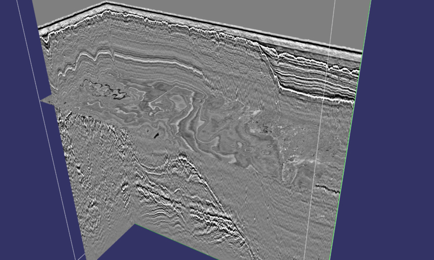
How Fugro’s SeisWind 3D UUHR system is informing the safe development of offshore wind farm projects.
Geo-data specialist Fugro has completed a series of testing configurations for its new SeisWind 3D ultra ultra high resolution (UUHR) seismic system off the coast of the Netherlands.
The system is designed to enable detailed ground modelling and interpretation of near surface geology to inform the safe development of offshore projects in the energy, infrastructure and water industries.
The merits of precision mapping
Powerful surveying tools such as LIDAR have been improving navigation precision within the transport sector for some time, while augmented reality (AR) technologies have been deployed to improve planning for rights-of-way and production facilities within the oil and gas industry.
Elsewhere, various mining and offshore operations are benefiting from the merits of unmanned aerial vehicles (UAVs), also known as drones, that are equipped with GPS and are capable of carrying out surveys in the fraction of the time of conventional ground surveying methods. Precision mapping and modelling has also been used in the past to find suitable sites for new wind farms both onshore and offshore.
The SeisWind 3D system
Offering an efficient data acquisition footprint in UUHR, SeisWind 3D gives engineers the ability to acquire precise data across shorter time periods, and is slated to improve project development schedules, lower HSSE risk for offshore crew by reducing operational exposure hours, and mitigate potential project risks.
SeisWind 3D is an evolution of Fugro’s UUHR seismic service, made up of eight solid custom specification digital streamers, with proprietary sources and decimetre accuracy in-sea positioning systems.
Data captured by the system is processed by Fugro’s in-house experts using its latest UUHR seismic imaging developments, from which detailed ground models of offshore wind farms can be created to assist offshore asset installation planning.
“I am very excited to announce the successful delivery of our SeisWind 3D UUHR system that will offer our clients an efficient acquisition method whilst respecting fundamental geophysical principles to enable our in-house data delivery teams to provide the highest quality data,” said Blair McGunnigle, Fugro’s seismic data acquisition product owner.
“Understanding near surface geology and de-risking shallow hazards is critical as we continue to support the safe development of complex offshore projects.”