A real-world case study from a copper mine in Kazakhstan showcases the merits of UAVs in modern mining operations
A real-world case study from a copper mine in Kazakhstan showcases the merits of UAVs in modern mining operations
Mine operators know that safety precautions are of the utmost importance in the daily routine at a mining site. Conventional surveying methods involved considerable effort and resources on the ground.
Starting with electronic tachometers and later with ground GPS, surveyors have had to enter high-risk areas on the ground and spend considerable time to complete a survey. Some of the most acidic areas cannot even be entered as the risk to health and safety is too high. When compared with conventional ground surveying, it has been proven that the use of drones – or unmanned aerial vehicles (UAVs) – for surveying immensely reduces the exposure to risk for surface workers involved on site.
Instead of walking a mining site with ground equipment, areas of any risks involved are surveyed by flying over the site. UAV surveys can be done in a fraction of the time of a ground survey and generally provide higher accuracies. Surveying projects that usually take weeks with conventional surveying methods can now be completed in just a few hours. Hence, UAV technology minimises risks while reducing costs and boosting productivity.
KAZAKHSTAN CASE STUDY
In a recent project, Quest UAV was asked by Kaz Minerals to help raise safety and efficiency to a higher level than ever before at one of the biggest open-pit mines in eastern Kazakhstan. Two local teams (eight people) went through an extensive two-week training programme on professional flight operations and aerial open-pit surveying with a QuestUAV 200 Surveyor.
Following training by QuestUAV, both teams now fly the two Q-200 Surveyors on a daily basis, with the following objectives:
• To monitor mine status
• To monitor and plan pit and leach pad progress
• To map and plan infrastructure (roads, buildings)
• To monitor the perimeter security fence
• To estimate stock pile volumes
• To monitor and plan site rehabilitation
Kaz Minerals is focused on copper mining, producing both copper cathode from oxide ore and copper in concentrate. The pit development started in early 2013, supported by extensive surveys on the ground. It is predicted that the mine will become the biggest mining operation in Kazakhstan within the next three years. A crucial part of Kaz Minerals’ strategy for a safe and efficient pit development is to replace conventional survey methods with the latest UAV technology. The company decided to go with QuestUAV as it provides a robust and stable system for difficult environments, high-quality sensors and ongoing support for the flight operations.
EQUIPMENT AND DATA ACQUISITION
Since September 2016 Kaz Minerals has surveyed its mining sites and expansion areas on a daily basis with the two Q-200 Surveyors. Each UAV carries a Sony A6000 camera with a 16mm wide-angle lens providing image data down to 2.9cm GSD at 400ft. The images are the basis for 3D models, topographic site maps, infrastructure maps, pit volume estimations as well as maps for security and surveillance. Geospatial accuracy (cm-level) is achieved by combining image data with a combination of permanent and temporal ground control points (GCPs) distributed over the mining site.
Generally, the Q-200 Surveyor has been designed to complete high-quality aerial surveys in the quickest way possible in any environments ranging from desert and tropic to glacial and Arctic/Antarctic. The automatic camera trigger and the gimballed camera system allow the UAV to take pin-sharp pictures even at high wind speeds of up to 55km/h.
The UAV is launched with a bungee launch line and is either landed via parachute or belly landing. The latest version comes with a post-processing-kinematic (PPK) option, which provides high mapping accuracies down to 3cm without the need of physical ground control points.
APPLICATIONS
Daily flight missions have become an essential part of the Kaz Minerals site planning and mine development. The work of the flight team forms the basis for all further work in developing the mineral resources – distributing information to engineers, planners and geologists.
Aerial measurements are used to develop and display the plans, maps and profiles required for mining and exploration. Three of the major applications are explained in the
following sections.
MINE STATUS
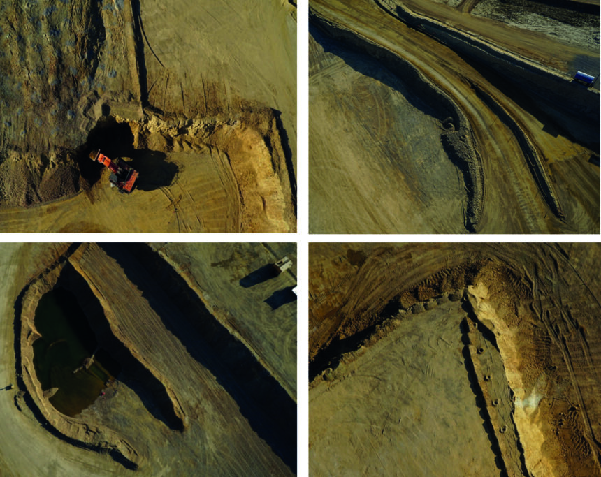
The basic application of the survey results is to provide a general overview of the status of the mine. Orthomosaic, digital surface model (DSM) and 3D point clouds are used to keep the Kaz Minerals management up-to-date about recent developments in the open-pit and the leach pad. The figure on the right shows sections of the orthomosaic, illustrating the level of detail gained from the UAV data.
SITE DEVELOPEMENT
Orthomosaic and DSM are the basis for an in-depth topographic analysis of the development of the mining site. Valuable information can be extracted from orthomosaic and DSM, such as infrastructure maps (roads, buildings), water bodies, contour lines, the flow of water, risk maps, etc. These datasets, in combination with expert knowledge of mining personnel, are used for the development of intelligent management plans for the development of the mine.
VOLUME ESTIMATIONS
UAV-based measurements are the fastest and easiest way to measure stockpile volumes. Photogrammetric software, such as Pix4Dmapper or Agisoft Photoscan allows users to automatically calculate volumes on the basis of aerial imagery. Kaz Minerals has proven that UAV-based measurements are not only faster but geodetic accuracies are also even higher when measurements are taken from a UAV.
VOLUME CALCULATIONS
Volume calculations are performed on the basis of the DSM. The difference between the base elevation of a pile and the pile elevation is the cut volume – when the terrain is higher than the base. Fill volume is the volume between the base and the terrain when the terrain is lower than the base. The total volume is the sum of cut volume and fill volume.
CLIENT ASSESSMENT
Kaz Minerals stated that the QuestUAV system greatly improved the surveying work at the mining site in terms of: improved worker safety; higher efficiency; increased site development productivity; and higher accuracies of the geodetic work. Today, UAV surveys are the basis for all further work related to developing the mining site, including engineers, planners and geologists.